
Thank you for supporting this site ❤️
Make a donation
Make a donation
Gunung Keriang topographic map
Click on the map to display elevation.
Thank you for supporting this site ❤️
Make a donation
Make a donation
About this map
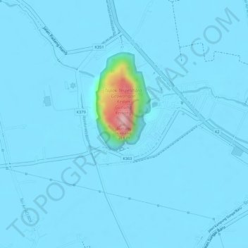
Name: Gunung Keriang topographic map, elevation, terrain.
Location: Gunung Keriang, Alor Setar, Kota Setar, Kedah, 06570, Malaysia (6.18712 100.33166 6.18722 100.33176)
Average elevation: 10 m
Minimum elevation: 1 m
Maximum elevation: 193 m
Thank you for supporting this site ❤️
Make a donation
Make a donation
Other topographic maps
Click on a map to view its topography, its elevation and its terrain.