
Thank you for supporting this site ❤️
Make a donation
Make a donation
La Borie Haute topographic map
Click on the map to display elevation.
Thank you for supporting this site ❤️
Make a donation
Make a donation
About this map
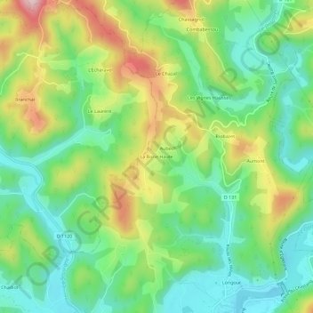
Name: La Borie Haute topographic map, elevation, terrain.
Average elevation: 281 m
Minimum elevation: 173 m
Maximum elevation: 469 m
Thank you for supporting this site ❤️
Make a donation
Make a donation
Other topographic maps
Click on a map to view its topography, its elevation and its terrain.
Saint-Bazile-de-la-Roche
France > Nouvelle-Aquitaine > Corrèze > Argentat-sur-Dordogne
Average elevation: 397 m