
Le Prévoux topographic map
Interactive map
Click on the map to display elevation.
About this map
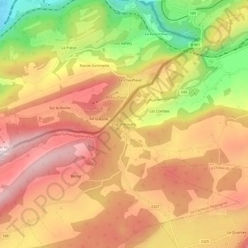
Name: Le Prévoux topographic map, elevation, terrain.
Location: Le Prévoux, Le Locle, Neuchâtel, 2400, Suisse (47.01848 6.68228 47.05848 6.72228)
Average elevation: 1,060 m
Minimum elevation: 750 m
Maximum elevation: 1,273 m
Other topographic maps
Click on a map to view its topography, its elevation and its terrain.
Vauladray
Suisse > Neuchâtel > Le Locle > Les Brenets
Vauladray, Les Brenets, Le Locle, Neuchâtel, 2416, Suisse
Average elevation: 944 m
Les Brenets
Les Brenets, Le Locle, Neuchâtel, 2416, Suisse
Average elevation: 941 m