
Thank you for supporting this site ❤️
Make a donation
Make a donation
Sadat topographic map
Click on the map to display elevation.
Thank you for supporting this site ❤️
Make a donation
Make a donation
About this map
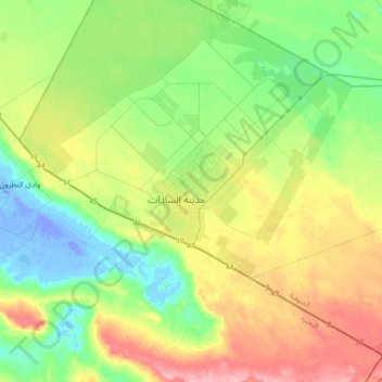
Name: Sadat topographic map, elevation, terrain.
Location: Sadat, Al Minufiya, 32921, Egypt (30.21201 30.36148 30.53201 30.68148)
Average elevation: 38 m
Minimum elevation: -28 m
Maximum elevation: 108 m
Thank you for supporting this site ❤️
Make a donation
Make a donation
Other topographic maps
Click on a map to view its topography, its elevation and its terrain.