
East Okoboji Lake topographic map
Interactive map
Click on the map to display elevation.
About this map
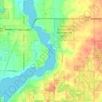
Name: East Okoboji Lake topographic map, elevation, terrain.
Average elevation: 448 m
Minimum elevation: 424 m
Maximum elevation: 476 m
Other topographic maps
Click on a map to view its topography, its elevation and its terrain.
Alta Vista
Estados Unidos de América > Iowa > Chickasaw County
Alta Vista, Chickasaw County, Iowa, Estados Unidos de América
Average elevation: 360 m
Moravia
Estados Unidos de América > Iowa > Appanoose County
Moravia, Appanoose County, Iowa, Estados Unidos de América
Average elevation: 300 m