
Make a donation
San Bernardino topographic map
Click on the map to display elevation.
Make a donation
San Bernardino
San Bernardino features a hot-summer Mediterranean climate (Csa in the Köppen climate classification) with mild winters and hot, dry summers. Relative to other areas in Southern California, winters are colder, with frost and with chilly to cold morning temperatures common. The particularly arid climate during the summer prevents tropospheric clouds from forming, meaning temperatures rise to what is considered by NOAA scientists as Class Orange. Summer thus has temperatures approaching those typical of hot desert climates, with the highest recorded summer temperature at 118 °F (47.8 °C) on July 6, 2018. In the winter, snow flurries occur upon occasion. San Bernardino gets an average of 16 inches (406 mm) of rain, hail, or light snow showers each year. Arrowhead Springs, San Bernardino's northernmost neighborhood gets snow, heavily at times, due to its elevation of about 3,000 feet (910 m) above sea level.
Make a donation
About this map
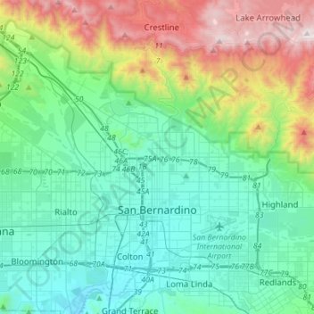
Name: San Bernardino topographic map, elevation, terrain.
Average elevation: 571 m
Minimum elevation: 262 m
Maximum elevation: 1,868 m
Make a donation
Other topographic maps
Click on a map to view its topography, its elevation and its terrain.
Big Bear City
United States > California > San Bernardino County
It is estimated that the Serrano natives first settled in Big Bear between 1,500 and 2,000 years ago. The Serranos had both winter and summer settlements throughout the area. While their winter village was located in Lucerne Valley, they relocated to villages in the San Bernardino mountains during summer, as…
Average elevation: 2,155 m
Fort Irwin
United States > California > San Bernardino County
Fort Irwin National Training Center (Fort Irwin NTC) is a major training area for the United States military in the Mojave Desert in northern San Bernardino County, California. Fort Irwin is at an average elevation of 2,454 feet (748 m). It is located 37 miles (60 km) northeast of Barstow, in the Calico…
Average elevation: 785 m
Make a donation
San Gorgonio Mountain
United States > California > San Bernardino County
Since it is the highest point in a region which is separated from higher peaks (e.g. in the Sierra Nevada) by relatively low terrain, San Gorgonio Mountain is one of the most topographically prominent peaks in the United States. It is ranked 7th among peaks in the 48 contiguous states and 18th overall.
Average elevation: 3,154 m
East Colton Heights
United States > California > San Bernardino County > Colton
Average elevation: 326 m
Make a donation
Make a donation
San Bernardino
United States > California > San Bernardino County > San Bernardino
Average elevation: 656 m