
Thank you for supporting this site ❤️
Make a donation
Make a donation
La Ville topographic map
Click on the map to display elevation.
Thank you for supporting this site ❤️
Make a donation
Make a donation
About this map
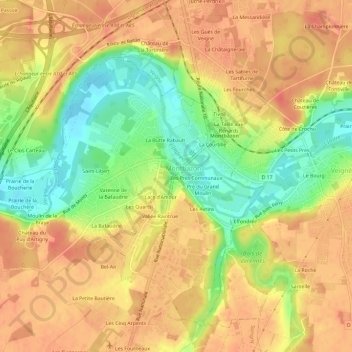
Name: La Ville topographic map, elevation, terrain.
Average elevation: 78 m
Minimum elevation: 46 m
Maximum elevation: 97 m
Thank you for supporting this site ❤️
Make a donation
Make a donation
Other topographic maps
Click on a map to view its topography, its elevation and its terrain.
Château d'Artigny
France > Centre-Val de Loire > Indre-et-Loire > Montbazon > Moulin de la Braye
Average elevation: 76 m