
Hogen topographic map
Interactive map
Click on the map to display elevation.
About this map
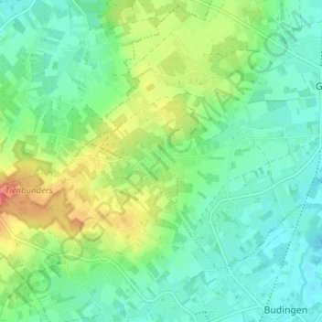
Name: Hogen topographic map, elevation, terrain.
Location: Hogen, Geetbets, Leuven, Vlaams-Brabant, 3450, België (50.86246 5.06006 50.90246 5.10006)
Average elevation: 43 m
Minimum elevation: 23 m
Maximum elevation: 85 m
Other topographic maps
Click on a map to view its topography, its elevation and its terrain.
Hulsbeek
België > Vlaams-Brabant > Leuven > Geetbets
Hulsbeek, Geetbets, Leuven, Vlaams-Brabant, 3450, België
Average elevation: 32 m
Bergen
België > Vlaams-Brabant > Leuven > Geetbets
Bergen, Geetbets, Leuven, Vlaams-Brabant, 3450, België
Average elevation: 42 m
Glabbeek
België > Vlaams-Brabant > Leuven > Geetbets
Glabbeek, Geetbets, Leuven, Vlaams-Brabant, Vlaanderen, 3450, België
Average elevation: 37 m