
Perth topographic map
Interactive map
Click on the map to display elevation.
About this map
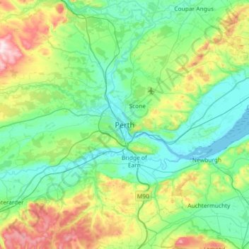
Name: Perth topographic map, elevation, terrain.
Location: Perth, Perth and Kinross, Scotland, PH1 5SU, United Kingdom (56.23582 -3.58868 56.55582 -3.26868)
Average elevation: 131 m
Minimum elevation: -1 m
Maximum elevation: 583 m
Other topographic maps
Click on a map to view its topography, its elevation and its terrain.
Coupar Angus
United Kingdom > Scotland > Perth and Kinross
Coupar Angus, Perth and Kinross, Scotland, PH13 9DA, United Kingdom
Average elevation: 70 m
Blacklunans
United Kingdom > Scotland > Perth and Kinross
Blacklunans, Perth and Kinross, Scotland, PH10 7LL, United Kingdom
Average elevation: 357 m
Crieff
United Kingdom > Scotland > Perth and Kinross
Crieff, Perth and Kinross, Scotland, PH7 3BS, United Kingdom
Average elevation: 115 m
Forgandenny
United Kingdom > Scotland > Perth and Kinross
Forgandenny, Perth and Kinross, Scotland, PH2 9EQ, United Kingdom
Average elevation: 53 m
Blairgowrie and Rattray
United Kingdom > Scotland > Perth and Kinross > Blairgowrie and Rattray
Blairgowrie and Rattray, Perth and Kinross, Scotland, PH10 6AB, United Kingdom
Average elevation: 121 m
Kindallachan
United Kingdom > Scotland > Perth and Kinross
Kindallachan, Perth and Kinross, Scotland, PH9 0NW, United Kingdom
Average elevation: 162 m