
Make a donation
Kakheti topographic map
Click on the map to display elevation.
Make a donation
Kakheti
The Kakheti Wine Region is located in the eastern part of Georgia and comprises two river basins, Iori and Alazani. These rivers have a significant influence on the character of Kakhetian wines. Kakheti is bordered on the west by another very important wine region of Georgia - Kartli. Together with the location, the climatic conditions of the region play an essential role in the formation of Kakheti wines. Kakheti vineyards are cultivated at an altitude of 250–800 meters above sea level. We can find both humid subtropicals as well as continental climates in the region. Kakheti terroir provides ideal conditions for both local varieties and international wine varieties as well. When talking about the Kakheti wine region, the first thing that comes to mind is Rkatsiteli and Saperavi grapes. These two wine varieties have become the face of the region and Georgia. With the increase in the awareness of Georgian wine, the interest in these varieties is growing, so do not be surprised if you encounter these Kakhetian wine varieties in different wine regions in the world.
Make a donation
About this map
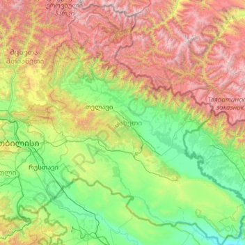
Name: Kakheti topographic map, elevation, terrain.
Location: Kakheti, Georgia (41.05513 45.02585 42.57397 46.73654)
Average elevation: 1,191 m
Minimum elevation: 78 m
Maximum elevation: 4,345 m
Make a donation
Other topographic maps
Click on a map to view its topography, its elevation and its terrain.
Gudauri
Georgia > Mtskheta-Mtianeti > Kazbegi Municipality
Gudauri (Georgian: გუდაური) is a ski resort located on the south-facing plateau of The Greater Caucasus Mountain Range in Georgia. The resort is situated in the Stepantsminda District, along the Georgian Military Highway near the Jvari Pass, at an elevation of 2,200 meters (7,200 ft.) above sea…
Average elevation: 2,161 m
Mestia
Georgia > Samegrelo-Upper Svaneti > Mestia Municipality
Mestia (Georgian: მესტია IPA: [mestʼia]) is a highland townlet (daba) in northwest Georgia, at an elevation of 1,500 metres (4,921 feet) in the Caucasus Mountains.
Average elevation: 1,749 m
Make a donation
Make a donation
mineral water
Georgia > Samegrelo-Upper Svaneti > Mestia Municipality > Ebudi > Lankhvri
Average elevation: 1,542 m
Make a donation
Enguri Dam
Georgia > Samegrelo-Upper Svaneti > Tsalenjikha Municipality > Potskho-Etseri
Average elevation: 618 m
Tabakhmela
Georgia > Autonomous Republic of Adjara > Khulo Municipality > Tabakhmela
Average elevation: 1,325 m