
Thank you for supporting this site ❤️
Make a donation
Make a donation
Ambérac topographic map
Click on the map to display elevation.
Thank you for supporting this site ❤️
Make a donation
Make a donation
Ambérac
The relief of the commune is that of a low plateau and a confluence of two valleys. The highest point in the commune is at an altitude of 101 m located on the western boundary. The lowest point is 46 m located along the Charente on the south-western boundary. The town was built on the banks of the river at 62 m above sea level.
Thank you for supporting this site ❤️
Make a donation
Make a donation
About this map
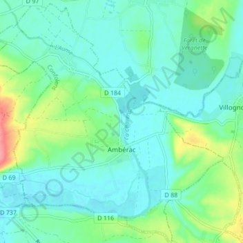
Name: Ambérac topographic map, elevation, terrain.
Average elevation: 66 m
Minimum elevation: 47 m
Maximum elevation: 126 m
Thank you for supporting this site ❤️
Make a donation
Make a donation
Other topographic maps
Click on a map to view its topography, its elevation and its terrain.