
Thank you for supporting this site ❤️
Make a donation
Make a donation
Ciater topographic map
Click on the map to display elevation.
Thank you for supporting this site ❤️
Make a donation
Make a donation
About this map
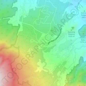
Name: Ciater topographic map, elevation, terrain.
Location: Ciater, Subang, West Java, Java, 41281, Indonesia (-6.75557 107.62589 -6.71557 107.66589)
Average elevation: 1,087 m
Minimum elevation: 811 m
Maximum elevation: 1,614 m
Thank you for supporting this site ❤️
Make a donation
Make a donation
Other topographic maps
Click on a map to view its topography, its elevation and its terrain.
PT.Sinkona Lestari Indoesia Backyard Park
Indonesia > West Java > Subang > Subang
Average elevation: 744 m