
Make a donation
Udyavara topographic map
Click on the map to display elevation.
Make a donation
About this map
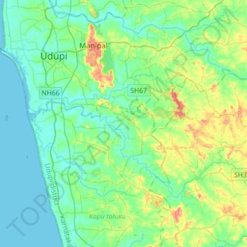
Name: Udyavara topographic map, elevation, terrain.
Average elevation: 30 m
Minimum elevation: -4 m
Maximum elevation: 136 m
Make a donation
Other topographic maps
Click on a map to view its topography, its elevation and its terrain.
Manipal
India > Karnataka > Udupi taluku
Manipal is a suburb and university town within Udupi, in coastal Karnataka, India. Manipal is located five kilometres away from the centre of Udupi City, in Udupi District, Karnataka (state) in south western India. It is administered by the Udupi City Municipality. The suburb is located in coastal Karnataka,…
Average elevation: 32 m
Udupi
India > Karnataka > Udupi taluku
Udupi has an elevation of 27 m (89 ft) above mean sea level. The climate in Udupi is hot in summers and pleasant in winter. During summers (from March to May) the temperature reaches up to 38 °C (100 °F) and in winters (from December to February) it is usually between 32 and 20 °C (90 and 68 °F). As it is…
Average elevation: 17 m
Make a donation
Make a donation
Bramhavara Akashavani
India > Karnataka > Udupi taluku > Brahmavara > Bramhavara Akashavani
Average elevation: 14 m
Manipal
India > Karnataka > Udupi taluku
Manipal (Kannada: [mɐɳipaːlɐ]) is a suburb and university town within Udupi, in coastal Karnataka, India. Manipal is located five kilometres away from the centre of Udupi City, in Udupi District, Karnataka (state) in south western India. It is administered by the Udupi City Municipality. The suburb is…
Average elevation: 32 m
Make a donation