
Make a donation
Nanticoke topographic map
Click on the map to display elevation.
Make a donation
Nanticoke
According to the United States Census Bureau, the city has a total area of 3.6 square miles (9.3 km2), of which 3.5 square miles (9.1 km2) is land and 0.1 square miles (0.26 km2), or 3.05%, is water. Nanticoke is located in the Wyoming Valley (near the Susquehanna River). The elevation is 696 feet (212 m). Both the Lower Broadway Street Bridge and the South Cross Valley Expressway cross over the Susquehanna River and connect Nanticoke with Plymouth Township. The topography of Nanticoke is hilly. The city can be divided into several sections: Honey Pot (northwestern Nanticoke), Downtown (northern and central Nanticoke), and Hanover Section (southeastern Nanticoke). Nanticoke Creek and Newport Creek run through the city.
Make a donation
About this map
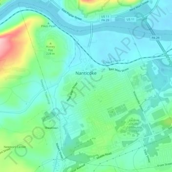
Name: Nanticoke topographic map, elevation, terrain.
Average elevation: 192 m
Minimum elevation: 152 m
Maximum elevation: 327 m
Make a donation
Other topographic maps
Click on a map to view its topography, its elevation and its terrain.
Make a donation
Make a donation
Roaring Brook
United States > Pennsylvania > Luzerne County > Hunlock Township
Average elevation: 337 m
Glen Summit
United States > Pennsylvania > Luzerne County > Fairview Township
Average elevation: 539 m
Make a donation
Town Hill
United States > Pennsylvania > Luzerne County > Huntington Township
Average elevation: 281 m
Make a donation
Liewellyn Corners
United States > Pennsylvania > Luzerne County > Bear Creek Township
Average elevation: 449 m
Wapwallopen
United States > Pennsylvania > Luzerne County > Conyngham Township
Average elevation: 223 m
Make a donation
Make a donation
Huntington Mills
United States > Pennsylvania > Luzerne County > Huntington Township
Average elevation: 289 m
Wapwallopen
United States > Pennsylvania > Luzerne County > Conyngham Township
Average elevation: 223 m
Make a donation
Hunlock Creek
United States > Pennsylvania > Luzerne County > Hunlock Township > Hunlock
Average elevation: 276 m
Make a donation
Fern Glen
United States > Pennsylvania > Luzerne County > Black Creek Township
Average elevation: 391 m
Ricketts Glen State Park
United States > Pennsylvania > Luzerne County > Fairmount Township
The state's original plans for the new park included building an inn, an 18-hole golf course and country club, and a winter sports complex for skiing, ice boating, and tobogganing, as well as a beach with bathing facilities, cabins, and a tent camping area. Only the last three were actually built, all south of…
Average elevation: 588 m
Make a donation
South Pond Dam
United States > Pennsylvania > Luzerne County > Hanover Township
Average elevation: 204 m
Fern Glen
United States > Pennsylvania > Luzerne County > Black Creek Township
Average elevation: 391 m
Make a donation