
São Jorge de Arroios topographic map
Interactive map
Click on the map to display elevation.
About this map
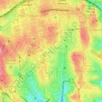
Name: São Jorge de Arroios topographic map, elevation, terrain.
Location: São Jorge de Arroios, Arroios, Lisboa, Portugal (38.72575 -9.14813 38.73722 -9.13119)
Average elevation: 77 m
Minimum elevation: 24 m
Maximum elevation: 113 m
Other topographic maps
Click on a map to view its topography, its elevation and its terrain.