
Thank you for supporting this site ❤️
Make a donation
Make a donation
Englehart topographic map
Click on the map to display elevation.
Thank you for supporting this site ❤️
Make a donation
Make a donation
About this map
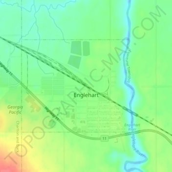
Name: Englehart topographic map, elevation, terrain.
Average elevation: 207 m
Minimum elevation: 184 m
Maximum elevation: 245 m
Thank you for supporting this site ❤️
Make a donation
Make a donation
Other topographic maps
Click on a map to view its topography, its elevation and its terrain.
Mindoka
Canada > Ontario > Timiskaming District > Unorganized West Timiskaming
Average elevation: 276 m
Mountain Peak
Canada > Ontario > Timiskaming District > Unorganized West Timiskaming
Average elevation: 255 m