
Thank you for supporting this site ❤️
Make a donation
Make a donation
Guayabero topographic map
Click on the map to display elevation.
Thank you for supporting this site ❤️
Make a donation
Make a donation
About this map
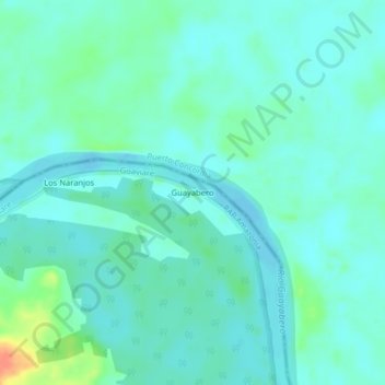
Name: Guayabero topographic map, elevation, terrain.
Average elevation: 185 m
Minimum elevation: 176 m
Maximum elevation: 219 m
Thank you for supporting this site ❤️
Make a donation
Make a donation
Other topographic maps
Click on a map to view its topography, its elevation and its terrain.
Reserva Forestal Protectora Serranía de La Lindosa
Colombia > Guaviare > San José del Guaviare
Average elevation: 220 m