
Korporation Ursern topographic map
Interactive map
Click on the map to display elevation.
About this map
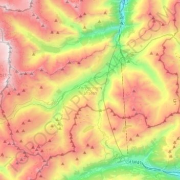
Name: Korporation Ursern topographic map, elevation, terrain.
Location: Korporation Ursern, Uri, Suisse (46.52763 8.40614 46.67706 8.68192)
Average elevation: 2,227 m
Minimum elevation: 915 m
Maximum elevation: 3,594 m
Other topographic maps
Click on a map to view its topography, its elevation and its terrain.
Andermatt
Suisse > Uri > Korporation Ursern
Andermatt, Korporation Ursern, Uri, 6490, Suisse
Average elevation: 2,127 m
Col de l'Oberalp
Suisse > Uri > Korporation Ursern > Andermatt
Col de l'Oberalp, Andermatt, Korporation Ursern, Uri, 6490, Suisse
Average elevation: 2,219 m
Glacier du Rhône
Glacier du Rhône, Westgrat, Obergoms, Korporation Ursern, Uri, Suisse
Average elevation: 2,798 m