
五大连池市 topographic map
Interactive map
Click on the map to display elevation.
About this map
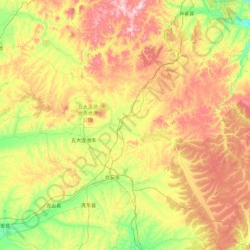
Name: 五大连池市 topographic map, elevation, terrain.
Location: 五大连池市, 黑河市, Heilongjiang, China (48.26019 125.70201 49.20034 127.53838)
Average elevation: 349 m
Minimum elevation: 226 m
Maximum elevation: 729 m
Other topographic maps
Click on a map to view its topography, its elevation and its terrain.
Амур
Амур, 漠河市, Regierungsbezirk Großes Hinggan-Gebirge, Heilongjiang, China
Average elevation: 260 m
松花江
China > Heilongjiang > Harbin
松花江, 宾县, Harbin, Heilongjiang, 132011, China
Average elevation: 310 m