
Montecatini Terme topographic map
Interactive map
Click on the map to display elevation.
About this map
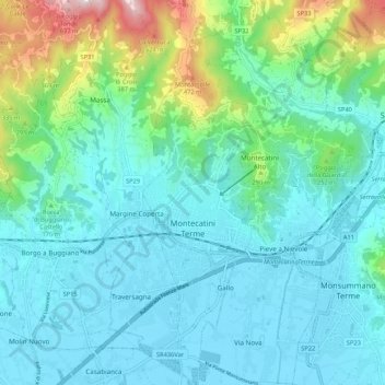
Name: Montecatini Terme topographic map, elevation, terrain.
Location: Montecatini Terme, Pistoia, Toskana, 51016, Italien (43.85177 10.75709 43.92848 10.81984)
Average elevation: 138 m
Minimum elevation: 13 m
Maximum elevation: 674 m
Other topographic maps
Click on a map to view its topography, its elevation and its terrain.
Lamporecchio
Italien > Toskana > Pistoia > Lamporecchio
Lamporecchio, Pistoia, Toskana, 51035, Italien
Average elevation: 132 m