
Thank you for supporting this site ❤️
Make a donation
Make a donation
Big Island topographic map
Click on the map to display elevation.
Thank you for supporting this site ❤️
Make a donation
Make a donation
About this map
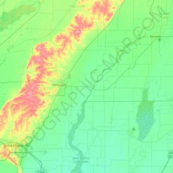
Name: Big Island topographic map, elevation, terrain.
Location: Big Island, Greene County, Arkansas, United States (35.73062 -90.69149 36.37062 -90.05149)
Average elevation: 84 m
Minimum elevation: 62 m
Maximum elevation: 167 m
Thank you for supporting this site ❤️
Make a donation
Make a donation
Other topographic maps
Click on a map to view its topography, its elevation and its terrain.