
Thalwil topographic map
Interactive map
Click on the map to display elevation.
About this map
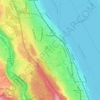
Name: Thalwil topographic map, elevation, terrain.
Location: Thalwil, Bezirk Horgen, Zürich, 8800, Zwitserland (47.27273 8.54230 47.30631 8.58966)
Average elevation: 471 m
Minimum elevation: 401 m
Maximum elevation: 616 m
Other topographic maps
Click on a map to view its topography, its elevation and its terrain.
Horgen
Zwitserland > Zürich > Bezirk Horgen
Horgen, Bezirk Horgen, Zürich, 8810, Zwitserland
Average elevation: 573 m