
Thank you for supporting this site ❤️
Make a donation
Make a donation
Le Quesnay topographic map
Click on the map to display elevation.
Thank you for supporting this site ❤️
Make a donation
Make a donation
About this map
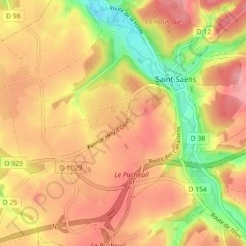
Name: Le Quesnay topographic map, elevation, terrain.
Average elevation: 156 m
Minimum elevation: 92 m
Maximum elevation: 196 m
Thank you for supporting this site ❤️
Make a donation
Make a donation
Other topographic maps
Click on a map to view its topography, its elevation and its terrain.
Bois Royal dit de l'Abbaye
France > Normandie > Seine-Maritime > Saint-Saëns > Le Camp Auger
Average elevation: 158 m