
Thank you for supporting this site ❤️
Make a donation
Make a donation
El Cofre topographic map
Click on the map to display elevation.
Thank you for supporting this site ❤️
Make a donation
Make a donation
About this map
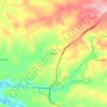
Name: El Cofre topographic map, elevation, terrain.
Location: El Cofre, Cajibío, Centro, Cauca, RAP Pacífico, Colombia (2.54831 -76.58523 2.58831 -76.54523)
Average elevation: 1,769 m
Minimum elevation: 1,658 m
Maximum elevation: 1,872 m
Thank you for supporting this site ❤️
Make a donation
Make a donation
Other topographic maps
Click on a map to view its topography, its elevation and its terrain.
Reserva Natural de la Sociedad Civil Suenos Verdes
Colombia > Cauca > Cajibío > Bajo Carrizal
Average elevation: 1,703 m