
Thank you for supporting this site ❤️
Make a donation
Make a donation
Meadow Vale topographic map
Click on the map to display elevation.
Thank you for supporting this site ❤️
Make a donation
Make a donation
About this map
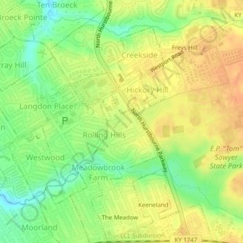
Name: Meadow Vale topographic map, elevation, terrain.
Location: Meadow Vale, Jefferson County, Kentucky, United States (38.27862 -85.57916 38.28950 -85.56675)
Average elevation: 201 m
Minimum elevation: 179 m
Maximum elevation: 217 m
Thank you for supporting this site ❤️
Make a donation
Make a donation
Other topographic maps
Click on a map to view its topography, its elevation and its terrain.
Iroquois Park
United States > Kentucky > Jefferson County > Louisville > Parkwood
Average elevation: 167 m
Thank you for supporting this site ❤️
Make a donation
Make a donation
Thank you for supporting this site ❤️
Make a donation
Make a donation
Thank you for supporting this site ❤️
Make a donation
Make a donation
Thank you for supporting this site ❤️
Make a donation
Make a donation
Thank you for supporting this site ❤️
Make a donation
Make a donation
Thank you for supporting this site ❤️
Make a donation
Make a donation
Thank you for supporting this site ❤️
Make a donation
Make a donation
Indian Hills Cherokee Section
United States > Kentucky > Jefferson County > Indian Hills
Average elevation: 168 m
E.P. "Tom" Sawyer State Park
United States > Kentucky > Jefferson County > Louisville > Lakeland
Average elevation: 209 m
Thank you for supporting this site ❤️
Make a donation
Make a donation