
Thank you for supporting this site ❤️
Make a donation
Make a donation
Gopiballabhpur topographic map
Click on the map to display elevation.
Thank you for supporting this site ❤️
Make a donation
Make a donation
Gopiballabhpur
Gopiballavpur is located at 22°12′N 86°53′E / 22.20°N 86.89°E / 22.20; 86.89. It has an average elevation of 34 metres (114 feet).
Thank you for supporting this site ❤️
Make a donation
Make a donation
About this map
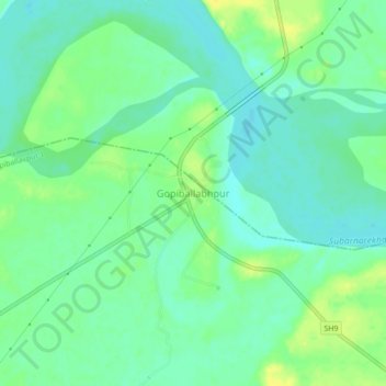
Name: Gopiballabhpur topographic map, elevation, terrain.
Average elevation: 40 m
Minimum elevation: 31 m
Maximum elevation: 52 m
Thank you for supporting this site ❤️
Make a donation
Make a donation