
Thank you for supporting this site ❤️
Make a donation
Make a donation
West Aberthaw topographic map
Click on the map to display elevation.
Thank you for supporting this site ❤️
Make a donation
Make a donation
About this map
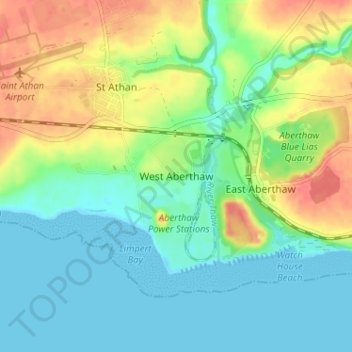
Name: West Aberthaw topographic map, elevation, terrain.
Average elevation: 19 m
Minimum elevation: 0 m
Maximum elevation: 51 m
Thank you for supporting this site ❤️
Make a donation
Make a donation
Other topographic maps
Click on a map to view its topography, its elevation and its terrain.
Thank you for supporting this site ❤️
Make a donation
Make a donation
Thank you for supporting this site ❤️
Make a donation
Make a donation
Cosmeston Lakes Country Park
United Kingdom > Wales > Vale of Glamorgan > Penarth
Average elevation: 26 m
Thank you for supporting this site ❤️
Make a donation
Make a donation
Thank you for supporting this site ❤️
Make a donation
Make a donation