
Municipio Sucre topographic map
Interactive map
Click on the map to display elevation.
About this map
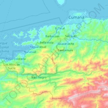
Name: Municipio Sucre topographic map, elevation, terrain.
Location: Municipio Sucre, Estado Sucre, Venezuela (10.06061 -64.53159 10.48853 -64.01029)
Average elevation: 476 m
Minimum elevation: -1 m
Maximum elevation: 2,414 m
Other topographic maps
Click on a map to view its topography, its elevation and its terrain.
Municipio Mariño
Municipio Mariño, Estado Sucre, 6156, Venezuela
Average elevation: 160 m
Rio Seco
Venezuela > Estado Sucre > Municipio Cajigal
Rio Seco, Parroquia Libertad, Municipio Cajigal, Estado Sucre, Venezuela
Average elevation: 39 m