
Moncofa topographic map
Click on the map to display elevation.
About this map
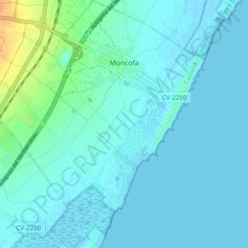
Name: Moncofa topographic map, elevation, terrain.
Average elevation: 5 m
Minimum elevation: -2 m
Maximum elevation: 32 m
Other topographic maps
Click on a map to view its topography, its elevation and its terrain.
Desert de les Palmes
Spain > Valencian Community > Castelló / Castellón > Benicàssim / Benicasim
Average elevation: 370 m
Vila-real
Spain > Valencian Community > Castelló / Castellón > Vila-real > Vila-real
Average elevation: 42 m
Cim del Montnegro
Spain > Valencian Community > Castelló / Castellón > Borriol
Average elevation: 346 m