
Constance topographic map
Interactive map
Click on the map to display elevation.
About this map
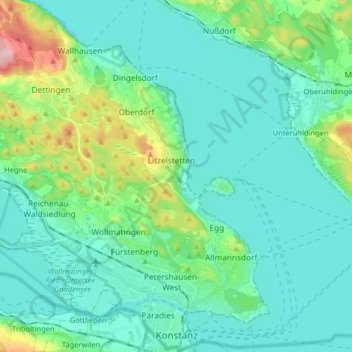
Name: Constance topographic map, elevation, terrain.
Average elevation: 420 m
Minimum elevation: 383 m
Maximum elevation: 577 m
Other topographic maps
Click on a map to view its topography, its elevation and its terrain.
Lac de Constance
Allemagne > Bade-Wurtemberg > Landkreis Konstanz
Lac de Constance, Landkreis Konstanz, Bade-Wurtemberg, Allemagne
Average elevation: 555 m