
Thank you for supporting this site ❤️
Make a donation
Make a donation
Cahama topographic map
Click on the map to display elevation.
Thank you for supporting this site ❤️
Make a donation
Make a donation
About this map
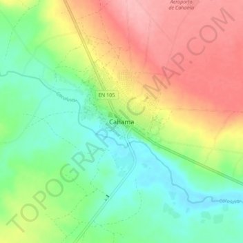
Name: Cahama topographic map, elevation, terrain.
Location: Cahama, Cunene Province, Angola (-16.32279 14.26251 -16.24279 14.34251)
Average elevation: 1,189 m
Minimum elevation: 1,139 m
Maximum elevation: 1,256 m
Thank you for supporting this site ❤️
Make a donation
Make a donation
Other topographic maps
Click on a map to view its topography, its elevation and its terrain.