
Thank you for supporting this site ❤️
Make a donation
Make a donation
Houghton topographic map
Click on the map to display elevation.
Thank you for supporting this site ❤️
Make a donation
Make a donation
About this map
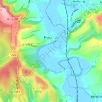
Name: Houghton topographic map, elevation, terrain.
Location: Houghton, Arun, West Sussex, England, United Kingdom (50.87454 -0.60842 50.90281 -0.54285)
Average elevation: 51 m
Minimum elevation: -3 m
Maximum elevation: 178 m
Thank you for supporting this site ❤️
Make a donation
Make a donation
Other topographic maps
Click on a map to view its topography, its elevation and its terrain.
Thank you for supporting this site ❤️
Make a donation
Make a donation
Thank you for supporting this site ❤️
Make a donation
Make a donation
Thank you for supporting this site ❤️
Make a donation
Make a donation