
Thank you for supporting this site ❤️
Make a donation
Make a donation
Baia Mare topographic map
Click on the map to display elevation.
Thank you for supporting this site ❤️
Make a donation
Make a donation
About this map
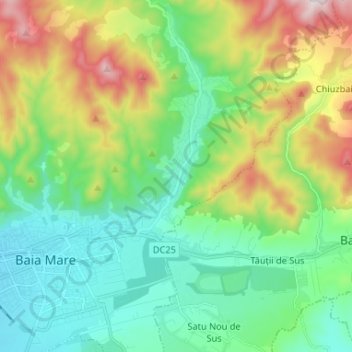
Name: Baia Mare topographic map, elevation, terrain.
Location: Baia Mare, Maramureș, Romania (47.63493 23.50772 47.72016 23.63868)
Average elevation: 414 m
Minimum elevation: 212 m
Maximum elevation: 878 m
Thank you for supporting this site ❤️
Make a donation
Make a donation
Other topographic maps
Click on a map to view its topography, its elevation and its terrain.
Baia Mare
The city is situated in the vicinity of the Gutâi and Igniș [ro] mountains. Altitudes reach 1,400 metres (4,600 feet) in some peaks. The area is famous for its outstanding landscapes, and the mountains are easily accessible from the city, notable routes being: Igniș (1,307 m), Mogoșa (1,246 m), Gutâi…
Average elevation: 592 m