
Thank you for supporting this site ❤️
Make a donation
Make a donation
Hollybush topographic map
Click on the map to display elevation.
Thank you for supporting this site ❤️
Make a donation
Make a donation
About this map
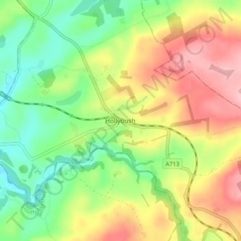
Name: Hollybush topographic map, elevation, terrain.
Location: Hollybush, East Ayrshire, Scotland, KA6 6RA, United Kingdom (55.38070 -4.55766 55.42070 -4.51766)
Average elevation: 129 m
Minimum elevation: 65 m
Maximum elevation: 208 m
Thank you for supporting this site ❤️
Make a donation
Make a donation
Other topographic maps
Click on a map to view its topography, its elevation and its terrain.
Thank you for supporting this site ❤️
Make a donation
Make a donation
Thank you for supporting this site ❤️
Make a donation
Make a donation