
Thank you for supporting this site ❤️
Make a donation
Make a donation
Estinnes topographic map
Click on the map to display elevation.
Thank you for supporting this site ❤️
Make a donation
Make a donation
About this map
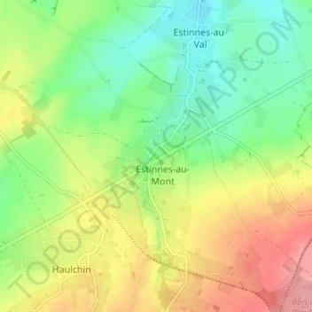
Name: Estinnes topographic map, elevation, terrain.
Location: Estinnes, La Louvière, Hainaut, Wallonie, 7120, Belgique (50.37767 4.07758 50.41767 4.11758)
Average elevation: 96 m
Minimum elevation: 55 m
Maximum elevation: 151 m
Thank you for supporting this site ❤️
Make a donation
Make a donation
Other topographic maps
Click on a map to view its topography, its elevation and its terrain.
Thank you for supporting this site ❤️
Make a donation
Make a donation
Bois Saint-Julien
Belgique > Hainaut > La Louvière > Strépy-Bracquegnies > Les Hubert
Average elevation: 71 m