
Thank you for supporting this site ❤️
Make a donation
Make a donation
Tungurahua topographic map
Click on the map to display elevation.
Thank you for supporting this site ❤️
Make a donation
Make a donation
Tungurahua
Generally though, Tungurahua experiences temperatures between 14 and 17 degree Celsius in the day-time, with cooler nights. At higher altitudes, conditions are much colder. Despite the area being near the Equator, mountains such as Carihuayrazo and Chimborazo are covered in snow for much of the year.
Thank you for supporting this site ❤️
Make a donation
Make a donation
About this map
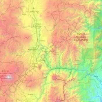
Name: Tungurahua topographic map, elevation, terrain.
Location: Tungurahua, Ecuador (-1.52314 -78.93798 -0.98815 -78.11020)
Average elevation: 3,118 m
Minimum elevation: 919 m
Maximum elevation: 6,259 m
Thank you for supporting this site ❤️
Make a donation
Make a donation
Other topographic maps
Click on a map to view its topography, its elevation and its terrain.