
Idmine topographic map
Interactive map
Click on the map to display elevation.
About this map
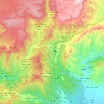
Name: Idmine topographic map, elevation, terrain.
Average elevation: 880 m
Minimum elevation: 168 m
Maximum elevation: 1,788 m
Other topographic maps
Click on a map to view its topography, its elevation and its terrain.
Tamait Oufella
Maroc > Cercle d'Agadir-Banlieue > Amskroud
Tamait Oufella, Amskroud, caïdat d'Amskroud, Cercle d'Agadir-Banlieue, Préfecture d'Agadir Ida-Outanane, Souss-Massa, Maroc
Average elevation: 252 m