
Make a donation
Quito topographic map
Click on the map to display elevation.
Make a donation
Quito
Quito (Spanish pronunciation: [ˈkito] ; Quechua: Kitu), officially San Francisco de Quito, is the capital of Ecuador, with an estimated population of 2.8 million in its metropolitan area. It is also the capital of the province of Pichincha. Quito is located in a valley on the eastern slopes of Pichincha, an active stratovolcano in the Andes, at an elevation of 2,850 m (9,350 ft), making it the highest or the second highest capital city in the world.
Make a donation
About this map
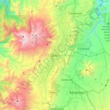
Name: Quito topographic map, elevation, terrain.
Location: Quito, Quito Canton, Pichincha, 170130, Ecuador (-0.38016 -78.67233 -0.06016 -78.35233)
Average elevation: 2,930 m
Minimum elevation: 1,897 m
Maximum elevation: 4,737 m
Make a donation
Other topographic maps
Click on a map to view its topography, its elevation and its terrain.
Cumbaya
At an elevation of 2200 m (7200 ft) above sea level, Cumbayá is lower than Quito and its climate is about 2 to 5 degrees Celsius warmer. Weather is semi tropical year-round, with a short rainy season.
Average elevation: 2,444 m
Make a donation
Cumbaya
At an elevation of 2200 m (7200 ft) above sea level, Cumbayá is lower than Quito and its climate is about 2 to 5 degrees Celsius warmer. Weather is semi tropical year-round, with a short rainy season.
Average elevation: 2,444 m
Make a donation
Guayllabamba
Guayllabamba (Kichwa: Wayllapampa, "green plain") is a small agricultural town (administratively, a rural parish of the canton of Quito) located 29 kilometers northeast of the city of Quito in northern Ecuador. In the 2001 census, the parish had a population of 12,227. The elevation is 2,142 metres (7,028 ft)…
Average elevation: 2,275 m
Make a donation
Make a donation