
Thank you for supporting this site ❤️
Make a donation
Make a donation
Ayer's Cliff topographic map
Click on the map to display elevation.
Thank you for supporting this site ❤️
Make a donation
Make a donation
About this map
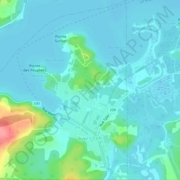
Name: Ayer's Cliff topographic map, elevation, terrain.
Location: Ayer's Cliff, Memphrémagog, Estrie, Quebec, Canada (45.16050 -72.07353 45.19009 -72.03218)
Average elevation: 172 m
Minimum elevation: 158 m
Maximum elevation: 242 m
Thank you for supporting this site ❤️
Make a donation
Make a donation
Other topographic maps
Click on a map to view its topography, its elevation and its terrain.
Scouts Canada - Lake Lovering Scouts Reserve
Canada > Quebec > Memphrémagog > Magog
Average elevation: 260 m
Thank you for supporting this site ❤️
Make a donation
Make a donation
Thank you for supporting this site ❤️
Make a donation
Make a donation