
Thank you for supporting this site ❤️
Make a donation
Make a donation
Pyinoolwin Township topographic map
Click on the map to display elevation.
Thank you for supporting this site ❤️
Make a donation
Make a donation
About this map
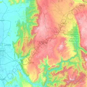
Name: Pyinoolwin Township topographic map, elevation, terrain.
Location: Pyinoolwin Township, Pyin Oo Lwin District, Mandalay, Myanmar (21.66859 96.24207 22.37175 96.76481)
Average elevation: 597 m
Minimum elevation: 66 m
Maximum elevation: 1,523 m
Thank you for supporting this site ❤️
Make a donation
Make a donation
Other topographic maps
Click on a map to view its topography, its elevation and its terrain.