
Thank you for supporting this site ❤️
Make a donation
Make a donation
Cepagatti topographic map
Click on the map to display elevation.
Thank you for supporting this site ❤️
Make a donation
Make a donation
About this map
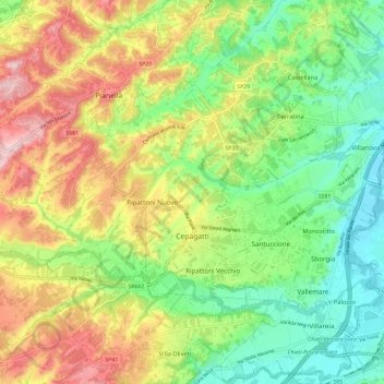
Name: Cepagatti topographic map, elevation, terrain.
Location: Cepagatti, Pescara, Abruzzo, 65012, Italy (42.33091 14.05751 42.41756 14.16182)
Average elevation: 125 m
Minimum elevation: 18 m
Maximum elevation: 277 m
Thank you for supporting this site ❤️
Make a donation
Make a donation
Other topographic maps
Click on a map to view its topography, its elevation and its terrain.
Thank you for supporting this site ❤️
Make a donation
Make a donation
Città Sant'Angelo
Italy > Abruzzo > Pescara > Città Sant'Angelo > Città Sant'Angelo
Average elevation: 123 m
Thank you for supporting this site ❤️
Make a donation
Make a donation