
Make a donation
Yardley topographic map
Click on the map to display elevation.
Make a donation
About this map
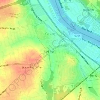
Name: Yardley topographic map, elevation, terrain.
Location: Yardley, Bucks County, Pennsylvania, United States (40.23162 -74.85164 40.25072 -74.82409)
Average elevation: 29 m
Minimum elevation: 6 m
Maximum elevation: 56 m
Make a donation
Other topographic maps
Click on a map to view its topography, its elevation and its terrain.
Croydon Heights
United States > Pennsylvania > Bucks County > Bristol Township > Croydon
Average elevation: 10 m
Langhorne Gardens
United States > Pennsylvania > Bucks County > Middletown Township
Average elevation: 45 m
Make a donation
Tyler State Park
United States > Pennsylvania > Bucks County > Northampton Township
Average elevation: 67 m
Pipersville
United States > Pennsylvania > Bucks County > Bedminster Township
Average elevation: 125 m
Plumsteadville
United States > Pennsylvania > Bucks County > Plumstead Township
Average elevation: 160 m
Make a donation
Falls Township Community Park
United States > Pennsylvania > Bucks County > Falls Township > Wheat Sheaf
Average elevation: 9 m
Blue Ridge
United States > Pennsylvania > Bucks County > Bristol Township > Levittown
Average elevation: 16 m
Make a donation
Wrightstown
United States > Pennsylvania > Bucks County > Wrightstown Township
Average elevation: 85 m
Mechanicsville
United States > Pennsylvania > Bucks County > Buckingham Township
Average elevation: 117 m
Make a donation
Kintnersville
United States > Pennsylvania > Bucks County > Nockamixon Township
Average elevation: 113 m
Southampton
United States > Pennsylvania > Bucks County > Upper Southampton Township
Average elevation: 75 m
Make a donation
Landisville
United States > Pennsylvania > Bucks County > Buckingham Township
Average elevation: 121 m
Springtown
United States > Pennsylvania > Bucks County > Springfield Township
Average elevation: 163 m
Make a donation
Southampton
United States > Pennsylvania > Bucks County > Upper Southampton Township
Average elevation: 75 m
Make a donation
Taylorsville
United States > Pennsylvania > Bucks County > Upper Makefield Township > Washington Crossing
Average elevation: 37 m
Make a donation
Blue Ridge
United States > Pennsylvania > Bucks County > Bristol Township > Levittown
Average elevation: 16 m
Blooming Glen
United States > Pennsylvania > Bucks County > Hilltown Township
Average elevation: 131 m
Make a donation
Croydon
United States > Pennsylvania > Bucks County > Bristol Township > Croydon
Average elevation: 8 m
Red Cedar Hill
United States > Pennsylvania > Bucks County > Bristol Township > Levittown > Red Cedar Hill
Average elevation: 21 m
Kintnersville
United States > Pennsylvania > Bucks County > Nockamixon Township
Average elevation: 113 m
Eddington Gardens
United States > Pennsylvania > Bucks County > Bensalem Township > Eddington Gardens
Average elevation: 29 m
Make a donation
Bridge Point
United States > Pennsylvania > Bucks County > Doylestown Township
Average elevation: 82 m