
Leicester topographic map
Interactive map
Click on the map to display elevation.
About this map
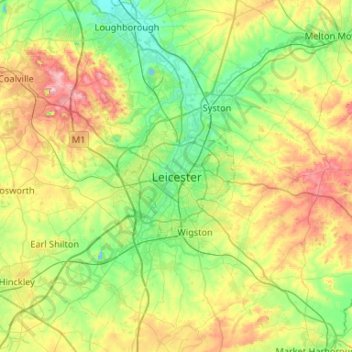
Name: Leicester topographic map, elevation, terrain.
Location: Leicester, Leicestershire, England, LE1 5YA, United Kingdom (52.47620 -1.29320 52.79620 -0.97320)
Average elevation: 109 m
Minimum elevation: 33 m
Maximum elevation: 269 m
Other topographic maps
Click on a map to view its topography, its elevation and its terrain.
Belton
United Kingdom > England > Leicestershire > North West Leicestershire
Belton, North West Leicestershire, Leicestershire, England, United Kingdom
Average elevation: 90 m
Charnwood
United Kingdom > England > Leicestershire
Charnwood, Leicestershire, England, United Kingdom
Average elevation: 92 m
Loughborough
United Kingdom > England > Leicestershire > Charnwood
Loughborough, Charnwood, Leicestershire, England, LE11 5BJ, United Kingdom
Average elevation: 61 m