
Thank you for supporting this site ❤️
Make a donation
Make a donation
Mathern topographic map
Click on the map to display elevation.
Thank you for supporting this site ❤️
Make a donation
Make a donation
About this map
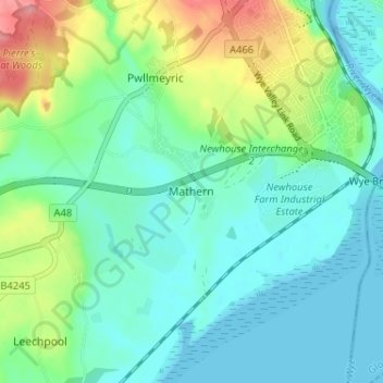
Name: Mathern topographic map, elevation, terrain.
Location: Mathern, Monmouthshire, Wales, NP16 6HZ, United Kingdom (51.59664 -2.71203 51.63664 -2.67203)
Average elevation: 27 m
Minimum elevation: -13 m
Maximum elevation: 101 m
Thank you for supporting this site ❤️
Make a donation
Make a donation
Other topographic maps
Click on a map to view its topography, its elevation and its terrain.
Thank you for supporting this site ❤️
Make a donation
Make a donation
Thank you for supporting this site ❤️
Make a donation
Make a donation