
Souli Municipality topographic map
Interactive map
Click on the map to display elevation.
About this map
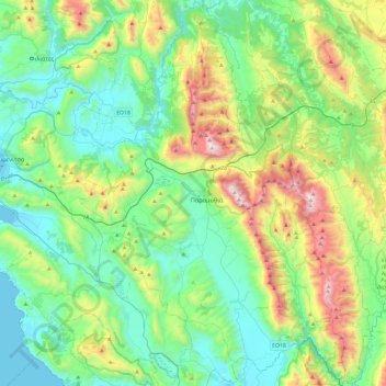
Name: Souli Municipality topographic map, elevation, terrain.
Average elevation: 423 m
Minimum elevation: -1 m
Maximum elevation: 1,627 m
Other topographic maps
Click on a map to view its topography, its elevation and its terrain.
Arillas
Greece > Epirus and Western Macedonia > Thesprotia Regional Unit > Perdika
Arillas, Perdika, Igoumenitsa Municipality, Thesprotia Regional Unit, Epirus, Epirus and Western Macedonia, 460 30, Greece
Average elevation: 94 m
Neraida
Greece > Epirus and Western Macedonia > Thesprotia Regional Unit > Neraida
Neraida, Souli Municipality, Thesprotia Regional Unit, Epirus, Epirus and Western Macedonia, 46200, Greece
Average elevation: 197 m
Φιλιάτες
Greece > Epirus and Western Macedonia > Thesprotia Regional Unit > Φιλιάτες
Φιλιάτες, Filiates Municipality, Thesprotia Regional Unit, Epirus, Epirus and Western Macedonia, 46300, Greece
Average elevation: 253 m
Prodromi
Greece > Epirus and Western Macedonia > Thesprotia Regional Unit > Prodromi
Prodromi, Souli Municipality, Thesprotia Regional Unit, Epirus, Epirus and Western Macedonia, 46200, Greece
Average elevation: 316 m