
Rhodes topographic map
Interactive map
Click on the map to display elevation.
About this map
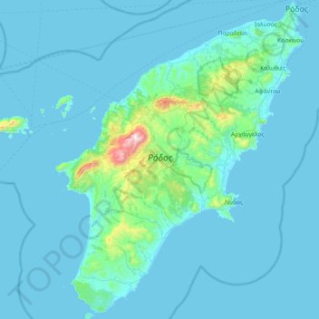
Name: Rhodes topographic map, elevation, terrain.
Location: Rhodes, Aegean, Greece (35.87666 27.68357 36.45828 28.24763)
Average elevation: 67 m
Minimum elevation: 0 m
Maximum elevation: 1,200 m
The Rhodian population of fallow deer was found to be genetically distinct in 2005, and to be of urgent conservation concern. In Petaloudes Valley (Greek for "Valley of the Butterflies"), large numbers of tiger moths gather during the summer months. Mount Attavyros, at 1,216 metres (3,990 ft), is the island's highest point of elevation.
Other topographic maps
Click on a map to view its topography, its elevation and its terrain.
Patmos
Greece > Aegean > Kalmynos Regional Unit > Patmos
Patmos, Patmos Municipality, Kalmynos Regional Unit, South Aegean, Aegean, 855 00, Greece
Average elevation: 15 m
Chios
Greece > Aegean > Chios Regional Unit
Chios, Chios Regional Unit, Northern Aegean, Aegean, Greece
Average elevation: 99 m
Thira Municipal Unit
Greece > Aegean > Thira Municipal Unit
Thira Municipal Unit, Δήμος Θήρας, Thira Regional Unit, South Aegean Region, Aegean, Greece
Average elevation: 12 m
Santorini
Greece > Aegean > Thira Municipal Unit
Santorini, Thira Municipal Unit, Δήμος Θήρας, Thira Regional Unit, South Aegean Region, Aegean, Greece
Average elevation: 30 m
Notio Aspronisi West
Notio Aspronisi West, Δήμος Λειψών, Kalmynos Regional Unit, South Aegean, Aegean, Greece
Average elevation: 2 m