
Angono River topographic map
Interactive map
Click on the map to display elevation.
About this map
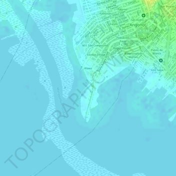
Name: Angono River topographic map, elevation, terrain.
Location: Angono River, Antipolo, Rizal, Calabarzon, 1870, Philippines (14.51523 121.14363 14.51774 121.14585)
Average elevation: 3 m
Minimum elevation: -1 m
Maximum elevation: 19 m
Other topographic maps
Click on a map to view its topography, its elevation and its terrain.
San Ysiro Valley
Philippines > Rizal > Antipolo > San Ysiro
San Ysiro Valley, San Ysiro, Antipolo, Rizal, Calabarzon, Philippines
Average elevation: 450 m
Kaysakat
Philippines > Rizal > Antipolo
Kaysakat, Antipolo, Rizal, Calabarzon, 1870, Philippines
Average elevation: 231 m
Rizza
Philippines > Rizal > Antipolo
Rizza, Antipolo, Rizal, Calabarzon, Philippines
Average elevation: 197 m
Wawa Dam
Philippines > Rizal > Antipolo
Wawa Dam, Antipolo, Rizal, Calabarzon, 1870, Philippines
Average elevation: 154 m
Apia
Philippines > Rizal > Antipolo
Apia, Antipolo, Rizal, Calabarzon, Philippines
Average elevation: 314 m
Boso-boso River
Philippines > Rizal > Antipolo
Boso-boso River, Antipolo, Rizal, Calabarzon, 1870, Philippines
Average elevation: 230 m
Libis
Philippines > Rizal > Antipolo
Libis, Antipolo, Rizal, Calabarzon, Philippines
Average elevation: 465 m
Mayamot
Philippines > Rizal > Antipolo
Mayamot, Antipolo, Rizal, Calabarzon, 1871, Philippines
Average elevation: 26 m
Bagong Nayon
Philippines > Rizal > Antipolo
Bagong Nayon, Antipolo, Rizal, Calabarzon, 1870, Philippines
Average elevation: 150 m
Kaliwa River
Philippines > Rizal > Antipolo
Kaliwa River, Antipolo, Rizal, Calabarzon, 1870, Philippines
Average elevation: 256 m
Dela Paz
Philippines > Rizal > Antipolo
Dela Paz, Antipolo, Rizal, Calabarzon, 1870, Philippines
Average elevation: 85 m
Santa Cruz
Philippines > Rizal > Antipolo
Santa Cruz, Antipolo, Rizal, Calabarzon, 1870, Philippines
Average elevation: 171 m
Hinulugang Taktak
Philippines > Rizal > Antipolo
Hinulugang Taktak, Antipolo, Rizal, Calabarzon, 1870, Philippines
Average elevation: 174 m
San Roque
Philippines > Rizal > Antipolo
San Roque, Antipolo, Rizal, Calabarzon, 1870, Philippines
Average elevation: 173 m
Muntindilaw
Philippines > Rizal > Antipolo
Muntindilaw, Antipolo, Rizal, Calabarzon, 1870, Philippines
Average elevation: 25 m
Dalig
Philippines > Rizal > Antipolo
Dalig, Antipolo, Rizal, Calabarzon, 1870, Philippines
Average elevation: 207 m
Calinawan Cave
Philippines > Rizal > Antipolo
Calinawan Cave, Calinawan Road, Rawang, Antipolo, Rizal, Calabarzon, 1870, Philippines
Average elevation: 188 m
Mount Pinto
Philippines > Rizal > Antipolo
Mount Pinto, Antipolo, Rizal, Calabarzon, 1870, Philippines
Average elevation: 591 m
Mount Pamitinan
Philippines > Rizal > Antipolo
Mount Pamitinan, Antipolo, Rizal, Calabarzon, 1870, Philippines
Average elevation: 168 m
San Isidro
Philippines > Rizal > Antipolo
San Isidro, Antipolo, Rizal, Calabarzon, 1870, Philippines
Average elevation: 192 m
Mount Sembrano
Philippines > Rizal > Antipolo
Mount Sembrano, Antipolo, Rizal, Calabarzon, 1870, Philippines
Average elevation: 427 m
Cupang
Philippines > Rizal > Antipolo
Cupang, Antipolo, Rizal, Calabarzon, 1873, Philippines
Average elevation: 172 m