
Reute topographic map
Interactive map
Click on the map to display elevation.
About this map
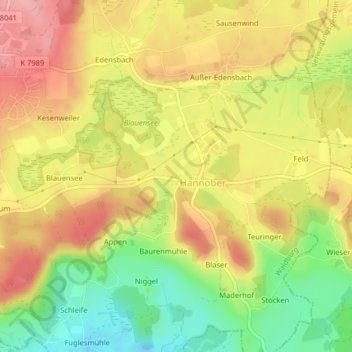
Name: Reute topographic map, elevation, terrain.
Average elevation: 662 m
Minimum elevation: 591 m
Maximum elevation: 721 m
Other topographic maps
Click on a map to view its topography, its elevation and its terrain.
Reute
Allemagne > Bade-Wurtemberg > Reute
Reute, Verwaltungsgemeinschaft Vogt, Landkreis Ravensburg, Regierungsbezirk Tübingen, Bade-Wurtemberg, 88267, Allemagne
Average elevation: 681 m