
Thank you for supporting this site ❤️
Make a donation
Make a donation
Saint-Galmier topographic map
Click on the map to display elevation.
Thank you for supporting this site ❤️
Make a donation
Make a donation
Saint-Galmier
Saint-Galmier is located in the western foothills of Mount Lyonnais. The center of the town is located in a valley, with a relatively flat terrain, with an elevation of 357 to 551 meters.
Thank you for supporting this site ❤️
Make a donation
Make a donation
About this map
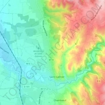
Name: Saint-Galmier topographic map, elevation, terrain.
Average elevation: 440 m
Minimum elevation: 355 m
Maximum elevation: 585 m
Thank you for supporting this site ❤️
Make a donation
Make a donation
Other topographic maps
Click on a map to view its topography, its elevation and its terrain.
Thank you for supporting this site ❤️
Make a donation
Make a donation
Valiant
France > Auvergne-Rhône-Alpes > Loire > Saint-Bonnet-des-Quarts > Le Royer
Average elevation: 623 m
Thank you for supporting this site ❤️
Make a donation
Make a donation
Thank you for supporting this site ❤️
Make a donation
Make a donation
Le Marthoret
France > Auvergne-Rhône-Alpes > Loire > Rive-de-Gier > Le Marthoret
Average elevation: 317 m
Thank you for supporting this site ❤️
Make a donation
Make a donation