
Thank you for supporting this site ❤️
Make a donation
Make a donation
Pleasant Garden topographic map
Click on the map to display elevation.
Thank you for supporting this site ❤️
Make a donation
Make a donation
About this map
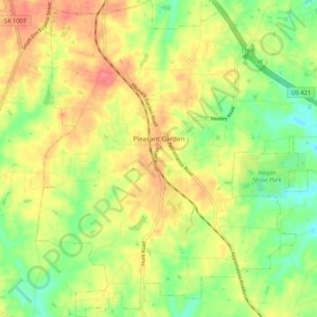
Name: Pleasant Garden topographic map, elevation, terrain.
Average elevation: 242 m
Minimum elevation: 209 m
Maximum elevation: 275 m
Thank you for supporting this site ❤️
Make a donation
Make a donation
Other topographic maps
Click on a map to view its topography, its elevation and its terrain.
Thank you for supporting this site ❤️
Make a donation
Make a donation
Piedmont Heights
United States > North Carolina > Guilford County > Greensboro
Average elevation: 251 m
Thank you for supporting this site ❤️
Make a donation
Make a donation
Sherwood Village
United States > North Carolina > Guilford County > High Point
Average elevation: 262 m
Thank you for supporting this site ❤️
Make a donation
Make a donation
Thank you for supporting this site ❤️
Make a donation
Make a donation
Melborne Heights
United States > North Carolina > Guilford County > High Point
Average elevation: 256 m
Thank you for supporting this site ❤️
Make a donation
Make a donation